 |
||
 |
"World Leader in GPS Tracking Software" |
|
| GEOTelematic® Solutions | ||
 |
GEOTelematic®
CelltracGTS™/Pro GPS Tracking Application for Android Phones
CelltracGTS™/Pro is the official Android phone GPS tracking application for OpenGTS® and the GeoTelematic® GTS Enterprise.
The CelltracGTS™/Pro application includes the following features:
- Supports selecting higher GPS sample rates for when the phone is in-motion, and less frequent GPS sample rates for when the phone is stopped. Ths allows providing a higher frequency of GPS locations and events while moving, but lower battery consumption while stopped. [Versions v1.6.4+ only]
- Improved GPS acquisition algorithm for providing locations with better accuracy when selecting less frequent GPS sample rates. [Versions v1.6.4+ only]
- Supports separate configuration profiles to allow tracking in different environments (ie. different vehicles, personal vs. business, etc).
- Provides the ability to keep the screen on (dim or bright) while tracking.
- Automatic event generation based on current GPS state analysis. Generates a "Start" of motion event when phone moves a selected distance from its original location, followed by periodic "In-Motion" events while moving, or "Heading-Change" events if the direction of travel changes. When the phone has come to rest for a selected period of time a "Stop" event is generated, followed by periodic "Dormant" events when the phone is still at rest.
- Displays an estimated "Odometer" based on accumulated distances between GPS points, which is also sent to the server with each event.
- Display a resettable "Tripometer" showing the distance travelled since last reset.
- Includes the battery level and battery temperature in event packet data sent to the server.
- Supports sending a "Low Battery Level" event to the server, when the battery level drops below a selected level.
- Provides the ability to send "impromptu" events with a specified message to the server.
- Suppports enabling an auto-start feature that will automatically start the CelltracGTS™/Pro application when the phone is restarted. [Versions v1.6.1+ only]
- Includes support for displaying tracked locations on a map on the phone.
- Includes support for displaying the last known locations of all account devices on a map on
the phone.
(requires the installation of either the "
events.war" servlet, or CelltracGTS™ DCS). - Provides the ability to save unsent events to auxiliary storage upon exiting application. These saved unsent events will be reloaded on the next launch of the application.
- Ability to enable an auto-start feature that will automatically start the application when the phone is restarted. [Versions v1.6.1+ only]
- Sends data to your own OpenGTS®
or GTS Enterprise
installation.
(using either the "
gprmc.war" servlet, or the CelltracGTS™ DCS). - Available currently in English (other translations available in a future release).
Additional features available when used with the CelltracGTS™ device communication server (DCS) module (running within the GTS Enterprise):
- Ability to transmit an unlimited number of unsent events to the server in one data transmission. (The "gprmc" DCS requires a separate data transmission for each unsent event).
- Provides the ability to select a specific device group on the "Group" map showing the last known location of other phones/vehicles/devices within the selected group.
Jump To:
- Downloading/Installing the CelltracGTS™/Pro app on your Android phone
- Main Application page field layout
- Application Settings
- Setting up the CelltracGTS™/Server (OpenGTS v2.5.8+ only)
- Setting up the OpenGTS® "gprmc" service
- Viewing the Messages sent with Impromptu Events
- Battery Usage while using the CelltracGTS™/Pro Application
- Change Logs
- Coming Soon
Downloading/Installing the CelltracGTS™/Pro app on your Android phone
The CelltracGTS™/Pro application is available from the Google Play Store and can be downloaded and installed onto your Android phone by scanning the QR code below, or by searching for CelltracGTS™/Pro in the Google Play Store.
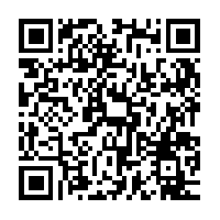
https://play.google.com/store/apps/details?id=org.opengts.client.android.cgtspro
Once installed, continue below to configure and use your CelltracGTS™/Pro application.
Any feedback you can provide (directly to the email below) regarding any suggestions, improvements, or general user experience, would be greatly appreciated.
Thank you very much,
CelltracGTS@geotelematic.com
Main Application page field layout
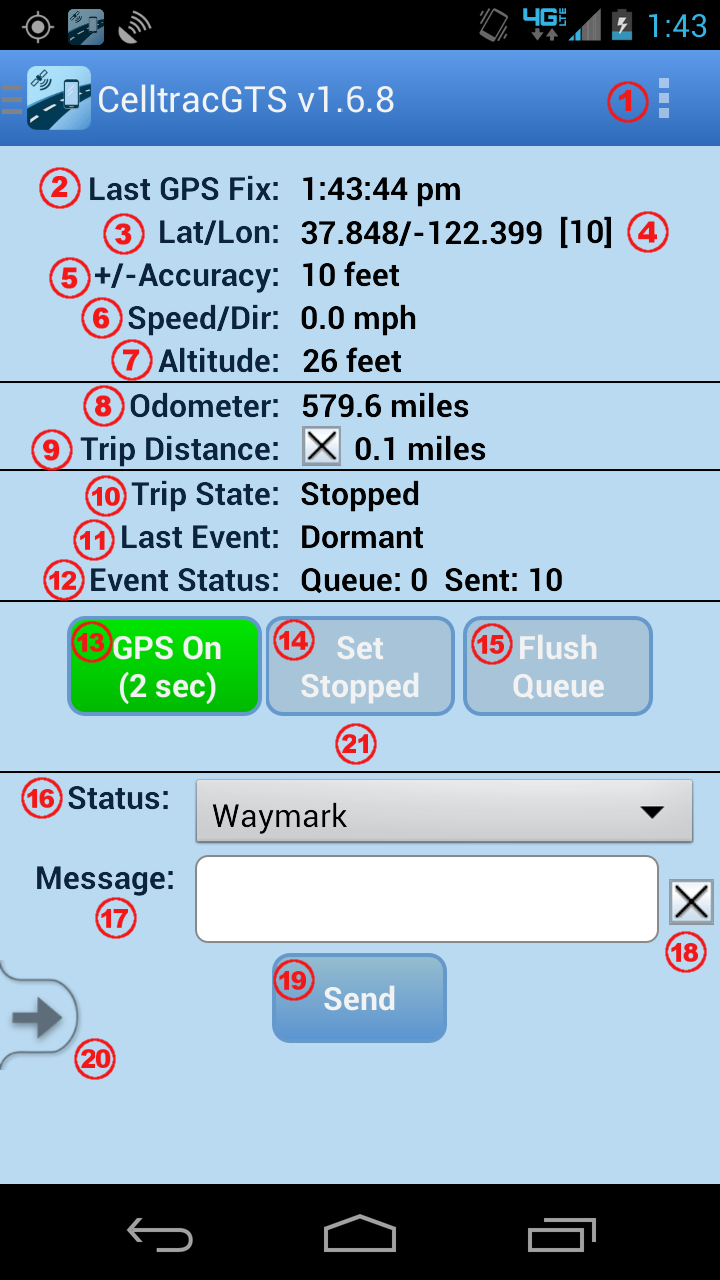
This section describes the various available fields on the main application page.
-
 Menu Button:
Pull-down menu where "Track Map", "Group Map", "Settings", "Help", "About", and "License", are displayed. (Please note that depending on your phone manufacturer and model, the location of your menu button may differ from the location displayed in the image). -
 Last GPS Fix:
The time of the most recently aquired GPS fix (relative to the local phone timezone). -
 Lat/Lon:
The most recently aquired GPS latitude/longitude. -
 Satellites:
The number of satellites used in the recent GPS fix. If the GPS fix was obtained from Network information, this value will be "[N]". -
 +/-Accuracy:
The relative accuracy of the recent aquired GPS fix. If this value is greater than the acceptable accuracy value selected on the Settings page, then the accuracy will also indicate "(rejected)". -
 Speed/Dir:
The Speed and Direction of the most recently aquired GPS fix. -
 Altitude:
The Altitude of the most recently aquired GPS fix. -
 Odometer:
The current odometer value calculated by the phone, based on accumulated distances between aquired GPS points. The initial value for the odometer can be set on the Settings page. -
 Trip Distance:
The resettable trip-distance value that displays the distance travelled since last rest. Clicking the "[X]" button resets the trip distance back to zero. -
 Trip State:
The current trip motion-state of the phone. Between a "Start" of motion event, and a "Stop" motion event, this value will show "En Route", indicating that a trip is in process. After a "Stop" motion event, this value will show "Stopped", indicating no trip in process. A "Trip" starts with the phone moving outside the bounds defined by "Distance to Trigger Motion", and continues until the phones stops for at least the amount of time defined by "Time to Full Stop". -
 Last Event:
The status code of the most recent event generated by the phone. -
 Event Status:
The current event queue status. "Queue:" indicates the number of events waiting in the queue to be sent to the server. "Sent:" indicates the number of events which have been sent to the server. -
 GPS On / GPS Off:
This button indicates the state of the GPS tracking on the phone. "GPS On" indicates that the GPS tracking is actively aquiring locations. The value within parenthesis (ie "(2 sec)") represents the current GPS sample rate. "GPS is Off" indicates that the GPS tracking has been suspended. Clicking on this button will cause the GPS tracking to toggle from On to Off, etc. When transitioning from "GPS On" to "GPS Off", any current "Moving" Trip Status will be set to "Stopped" (with the accompanying "Stop" event), then the GPS will be set to the "Suspend" state and a "GPS Suspend" event will be generated. The transition from "GPS Off" to "GPS On" will resume the GPS operation, and will generate a "GPS Resumed" event on the next received GPS location. -
 Set Stopped:
While "En Route" this button allows forcing a "Stop" event to occur without having to wait for the "Time to Full Stop" timeout to occur. This is useful when you have stopped at a location and want to immediately indicate a "Stop" event. -
 Flush Queue:
If "Minimum Transmit Interval" has been set to a value other than "immediate", this button allows specifying that any current events waiting in the event queue to be sent to the server should be sent as soon as possible (provided that the phone is in a data coverage area). This button may not be displayed if "Minimum Transmit Interval" is set to "immediate". -
 Status:
This pull-down menu allows selecting an impromptu event status-code type which can be manually generated and queued for sending to the server. -
 Message:
This field allows specifying a message that can be attached to the selected status code when sending an impromptu event to the server. -
 Clear Message:
This "[X]" button is intended as a convenient way to clear the message field. -
 Send:
Send:
This button allows creating a manually generated impromptu event, using the selected "Status Code" and entered Message, which will be queued for sending to the server. Select a desired "Status Code" from pull-down menu, enter an optional short message, then press the "Send" button. When the next GPS location is aquired, it will use this new location to generate an event with the selected status-code, which will then be queued for sending to the server. -
 Navigation Drawer Menu Button: [Versions v1.6.4+ only]
This is an alternate method for displaying the available menu options. To view, either client the arrow, or slide your finger from the left side of the screen toward the center of the screen. -
 Error/Warning Messages:
Error, warning, and other messages will be displayed in this area.
Application Settings
This section describes the various configurable options on the Settings page. To display the "Settings" page, press the "Menu" button, then select "Settings".
- Active Profile:
The CelltracGTS™ application supports saving multiple configuration settings to allow the phone to be used for tracking in different environments, such as tracking business trips vs. tracking personal trips, or for tracking different personal vehicles, etc. The "Active Profile" selection specifies the currently active profile settings to use for tracking within the current environment. When a new active profile is selected, all settings will automatically change to the last saved configuration for the selected profile.
Note: In order to also separate the tracked events on the server, the Mobile-ID may be slightly modified to reflect the selected profile. If the the "default" profile is selected, the MobileID is not modified, however if profile #1, #2, or #3, is selected, then the MobileID is appended with the profile number "-1", "-2", or "-3", respectively. The resulting MobileID will be displayed in the "Mobile ID" field, and this Mobile-ID can be added on the server as the Unique-ID to track the events into a separate Account/Device. For most common tracking purposes, this selection should remain as "default". - Profile Name:
This field allows assigning a name to the currently selected active profile. - Mobile ID Type:
This specifies which Unique-ID to use to identify the phone to the server. Selecting "IMEI / ESN" will use the 14 or 15 digit cell-phone radio identifier. Selecting "Android ID" will use the 16-character serial number assigned to the phone when first initialized. Note that if the device does not have a cell-phone radio, the "IMEI / ESN" selection will default to the "Android ID". - Mobile-ID: (read-only)
This read-only fields shows the unique mobile-id of the phone. This mobile-id will be either the IMEI/ESN number of the phone, or the Android-ID (serial number) assigned to the phone when it is first initialized (see "Mobile ID Type" selection for the preferred type). This mobile-id should be used on the server to identify the device and and associate it with an account. - Server URL:
The URL of the server must be specified in this field. When using the application with the open-source OpenGTS® server software, this URL will be of the form
http://SERVER:PORT/gprmc/Data
Where "SERVER:PORT" is the domain/ip-address and port of your server where the OpenGTS® software is installed. - Account ID (optional):
This Account-ID, along with the User-ID and Password, are used to retrieve the last known location information for all devices owned by this Account-ID, and display this information on the "Group Map". In order to use this feature, either the "events.war" servlet, or the CelltracGTS™ DCS, will need to be installed and running on your server. - User ID (optional):
This User-ID, along with the Account-ID and Password, are used to retrieve the last known location information for all devices owned by the Account-ID, and display this information on the "Group Map". If this field is left blank, the default User-ID will be assumed by the server. - Password (optional):
This field specifies the login password for the above specified Account/User. - Screen Power Mode:
This allows selecting whether the screen is allowed to go black, stay dim, or stay bright, while GPS tracking is active. Note that selecting "Dim" or "Bright" will cause increased battery consumption and attaching to a charger or other power source is recommended. - Location Provider:
This allows selecting the method of obtaining the phones current location. Selecting "GPS" provides the most accurate location information, however the GPS receiver will increase battery consumption. Selecting "Network" uses network information and does not provide accurate location information, however it also does not consume battery power as quickly. - GPS Sample Rate:
This allows selecting the rate at which new GPS locations will be acquired. Note that a more frequent GPS sample rate will end up consuming more power than a less frequent sample rate. - GPS Sample Rate (while stopped):
This allows selecting the rate at which new GPS locations will be acquired while the phone is stopped. Once the phone has come to a stop for the period of time established by the "Time To Full Stop" selection, the GPS sample rate will automatically switch to this selected value (if "disable" is selected, the standard "GPS Sample Rate" will remain). This allows for reduced battery consumption while not moving. However, please note that the app may not react to a start-of-motion condition until the next acquired GPS location. For instance, if you set the GPS Sample Rate while stopped to 3 minutes, then you could be 3 minutes down the road before the app detects motion and a "Start" event is generated. - Minimum Accuracy:
This allows selecting the minimum acceptable GPS location accuracy. GPS locations which have a accuracy value outside the accepted range will be rejected. - GPS Accuracy Timeout:
When the active GPS Sample Rate is 15 secods or greater, this timeout value specifies how long to wait to obtain a GPS fix that is within the selected GPS minimum accuracy (as selected on the "Minimum Accuracy" setting above). - Distance to Trigger Motion:
This specifies the minimum ditance the phone needs to move to trigger a start of motion event. - Event Interval While Moving:
This specifies the interval between generated events while the phone is in-motion (after the generation of the "Start" event). - Minimum Heading Change:
This specifies the minimum amount of heading change that must occur to generate a "Heading-Change" event. - Time To Full Stop:
When the phone is "En Route", this specifies the amount of time the phone must be stopped before generating a "Stopped" event. - Event Interval While Stopped:
This specifies the interval between generated events while the phone is stopped (after the generation of the "Stop" event). - Minimum Transmit Interval:
This specifies the minimum interval between event transmissions to the server, at which time any queued events will be sent to the server. Note that if the "gprmc" DCS is being used to receive data on the server, this may require multiple data transmissions. - Distance Units:
This specifies the preferred distance display units. Selecting "Miles" will also cause the accuracy and altitude units to change to "feet". Selecting "Kilometers" will also cause the accuracy and altitude units to change to "meters". - Odometer:
This allows entering the initial value for the Odometer calculation. - Distance To Trigger Odometer:
The Odometer value is normally calculated by accumulating the distances between generated events. This property allows selecting an additional minimum distance between locations to perform additional odometer calculations. This has the effect of creating a more accurate odometer value. Note that this odometer value is still calculated using GPS locations on the phone, and while it should approximate your actual vehicle odometer, it will not be exactly the same as your vehicle odometer. - Date Format:
This allows selecting the date format used for the "Last GPS Fix" date display on the main page. - Time Format:
This allows selecting the time format used for the "Last GPS Fix" time display on the main page. - Preferred Map Type:
This allows selecting the preferred map type to display when the "Track Map" or "Group Map" page is viewed. "Road" shows the standard road-page, "Satellite" shows a satellite-view image of the terrain, and "Hybrid" shows a combination of both the satellite-view and road-view. - Auto-Startup on Reboot: [v1.6.1+]
This allows selecting whether the CelltracGTS™ app should be automatically started when the phone is rebooted/restarted. Note that if the GPS was suspended prior to rebooting the phone, it will remain in the suspended state when CelltracGTS™ is restarted. - Color Theme: [v1.6.5+]
This allows selecting the preferred color theme for the displayed user interface. Currently available color-themes include "SkyBlue", "SteelBlue", "Gray", "White", and "Black". - Available Update Notification:
The application will check for possible updated versions on launch. If an update is available, it will be indicated next to the application version on the About page with the text "(update available)". This selection allows specifying whether whether a popup notification will also be presented when a new CelltracGTS™ application version is detected. - Report Errors:
When set to "Yes", any critical errors which cause the application to terminate will be reported to GeoTelematic Solutions to help with improving the CelltracGTS™ application.
Setting up the CelltracGTS™/Server
CelltracGTS™/Server is an optimzed device commuication server (DCS) designed specifically for the CelltracGTS™ phone applications, and is now available for download and integration with OpenGTS® versions 2.5.8, or later. The "
gprmc" and "events" services are not needed for communication with
CelltracGTS™/Pro when CelltracGTS™/Server is installed.
Click here for information regarding the download and installation of CelltracGTS™/Server.
Setting up the "gprmc" and "event" services
The "
gprmc" device communication server (DCS) module comes with the OpenGTS®
distribution and can be used to receive events from the CelltracGTS™/Pro application.
The "events" service module also comes with the OpenGTS® distribution and
is used to read device/phone location events.
Click here for information regarding the download and installation of the "gprmc" and "event" services.
Viewing the Messages sent with Impromptu Events
When selecting a Status Code to send an impromptu event back to the server, CelltracGTS™/Pro also supports entering a short message that will be included with the event. When the server receives the event, the message will be stored in the EventData field "
driverMessage"".
However the GTS configuration will need to be checked to ensure that the message will be saved and
viewed on a report. The following FAQ entries describe how to view these sent messages in a report:
Battery Usage while using the CelltracGTS™/Pro Application
This application requires the use of the phone's GPS receiver to receive location information, and the phone's modem to transmit data to the server. Both of these operations can place a heavier load on your phones battery, requiring that the battery be charged more frequently. When using this application while in your vehicle, it is highly recommended that your phone be plugged into a power source within your vehicle.
When necessary to conserve battery power, the following suggestions may be useful:
- Choose a "GPS Sample Rate (while stopped)" of 2-minutes, or more. This GPS sample rate is used when the phone is stopped, and will allow the GPS to be turned off between GPS samples, conserving battery power.
- Choose a longer (less frequent) "GPS Sample Rate" (while moving). While a 2-second gps sample rate may provide immediate detection of motion conditions while in a moving vehicle, using a gps sample rate of 2-minutes, or more, might be sufficient if you are walking or riding a bike.
- Select a less-frequent "Event Interval While Moving". A less-frequent event reporting interval will generate fewer events, resulting in fewer connections to the server. Alternatively, use the CelltracGTS™ DCS, which supports sending an unlimited number of events all in one data transmission to the server. When using the CelltracGTS™ DCS, an additional Settings option is available that allows specifying the minimum server transmission interval.
- Turn off (disable) the "Minimum Heading Change" selection. This will also cause fewer events to be generated, resulting in fewer required connections to the server. Alternatively, use the CelltracGTS™ DCS, which supports sending an unlimited number of events all in one data transmission to the server.
- When you get to your destination, turn off the GPS in the application (ie. Press the green "GPS-On" to change it to red "GPS-Off"). This will prevent the app from continuing to query the GPS receiver for the current location. Remember to turn the GPS button back on when leaving for a new destination.
ChangeLog
v1.6.5
- Fix possible crash that can occur when an invalid server address is entered.
- Different "Color Themes" can now be selected. Currently available color themes include: SkyBlue, SteelBlue, Gray, White, and Black.
- Road, Satellite, and Hybrid map types can now be selected directly from the various map pages.
- Added a "Traffic" layer selection from the various map pages to display traffic congested areas on major roadways.
- Fixed Navigation Drawer feature for Android versions 2.3.5+ (API level 10+).
v1.6.4
- Added additional settings for "GPS Sample Rate (while stopped)", allowing the GPS to be turned off for short periods of time while the phone is stopped, conserving battery power.
- Added a "GPS Accuracy Timeout" to allow a higher accuracy GPS location when using longer GPS sample rates.
- Added additional help text on Settings page.
- Added sliding navigation drawer menu to provide a more consistent and easier menu access.
v1.6.2
- Added option to automatically start app on phone reboot (enabled on the Settings page).
- Option to save unsent events on exit can now be set to a default selection on the Settings page. The options are "Ask", "Always", and "Never".
- Added an alternate button for displaying the menu (to provide a consistant menu display option between different types of Android phones).
v1.6.1
- "Device Map" now returns to display the map of the most recently viewed selected device.
- "Device Map" now zooms in to the most recently received events, up to approximately a 2-mile radius.
- Includes support for setting a "Low-Battery Threshold", which will generate an event for sending to the server when the current battery level falls below the selected threshold.
v1.6.0
- Separate "Device Map" page. Supports viewing the most recent track from selected devices within the Account.
- Separate "Group Map" page. Supports viewing the last known location of all devices within the Account (supports additional groups selections when used with the CelltracGTS server).
Coming Soon
Features that will be available soon in new CelltracGTS™ applications:
CelltracGTS™/OBD:
This will be a separate application that provides the ability to capture vehicle engine diagnostic data from a Bluetooth device plugged into the OBDII port on your vehicle. Collected data will include Coolant-Temperature, RPM, Fuel-Level, VIN, and more (depending on the availability of the data on your specific vehicle). Collected data will be attached to events sent to your server and viewable in reports in the GTS Enterprise.